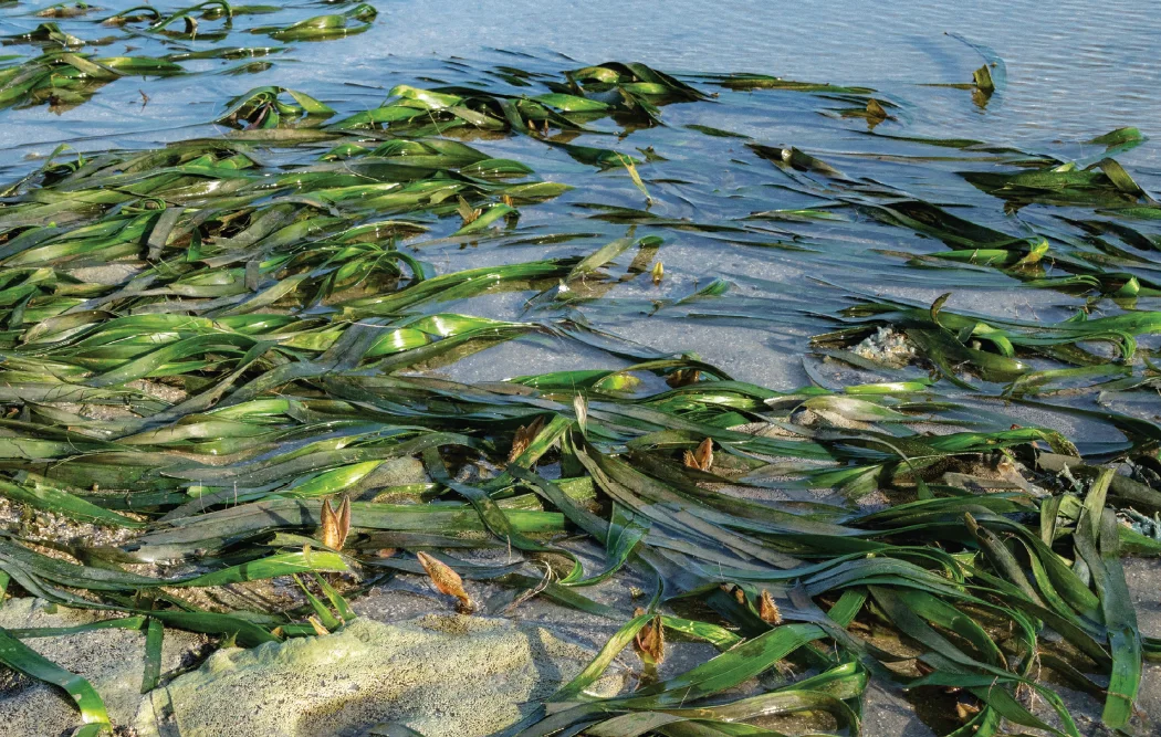
Seagrass exposed in the shallow coastal waters of Middle Bank.

DEVELOPMENT & THE LIVING COAST

What could development change?

Middle Bank’s future depends on decisions made around it. Examine the proposed Jelutong reclamation, the pathways of possible harm and the evidence needed to judge the risks.

The flowering seagrass, Enhalus acoroides is found on the Middle Bank. The seeds of these plants are a favourite food of the dugong.

UNDERSTAND THE RISK

A project boundary is not an ecological boundary.

Seagrass meadows, tidal flats and coastal waters exchange sediment, nutrients and organisms. Work at one location can therefore affect another through connected waters. The scale and direction of any effect must be tested against mapped habitats, seasonal observations and a calibrated coastal model—not inferred from proximity alone.

The proposal described in the EIA

This page refers to the Environmental Impact Assessment (EIA) version made publicly available on 12 February 2025 during the public feedback period. That version describes landfill rehabilitation and land reclamation for mixed development at Bandar Jelutong. Its Table 5.1 gives the following project areas:

70acres of proposed reclamation
90acres of landfill rehabilitation
160acres in the combined project area

Source: public-feedback EIA version made available on 12 February 2025, Chapter 5, Table 5.1, p. 5.1. These are proposal figures, not measured seagrass losses. Chapter 6, p. 6.35 places the project at “middle banks”; that description does not establish overlap with surveyed habitats or a legal sanctuary boundary. Later revisions and approval records must be checked separately. Check Table 5.1 in the EIA chapter ↗ · Read the source ↗

EXPERT WARNINGS

Protecting a meadow is easier than replacing it.

Marine scientists explain what is at stake for Middle Bank. Read the assessments reported on 21 March 2025 alongside Prof. Tan’s letter of 9 April 2025. The EIA discussion refers to the February 2025 public-feedback version.

EXPERT WARNINGS · 1

A warning about stress and recovery

The seagrass meadows are showing signs of stress, and we may be approaching a point of no return. If we do not act soon, we risk losing not only a biodiversity hotspot but also the ecosystem services that protect our shores and food systems.

Prof. Datuk Dr. Aileen Tan Shau HwaiDirector, Centre for Marine and Coastal Studies (CEMACS), Universiti Sains Malaysia · 2025

The Star · Letters ·

How to read this warning

In the same letter, Tan describes declining seagrass cover and physiological stress observed during the 2023–2024 heat wave. This is her dated warning about possible ecological change; it does not establish that an irreversible threshold has already been crossed.
EXPERT WARNINGS · 2

Look beyond the project boundary

Tan warned that the 500-metre zone described around the landfill and reclamation area would extend into about half of Middle Bank, raising concerns for the seagrass ecosystem.

Prof. Datuk Dr. Aileen Tan Shau HwaiDirector, Centre for Marine and Coastal Studies (CEMACS), Universiti Sains Malaysia — as identified in the report

Malaysiakini ·

How to read this warning

This is her reported interpretation of the proposal available in February 2025. The EIA’s 500 m land-use study radius is not an established ecological protection buffer, and this warning is not a surveyed measurement of habitat loss.

EXPERT WARNINGS · 3

Changed currents can damage seagrass

Ooi explained that development near sensitive habitats can change water movement, leading to siltation and sediment build-up that may smother seagrass.

Dr. Jillian OoiMarine ecologist, Universiti Malaya

Malaysiakini ·

How to read this warning

This describes a potential impact pathway. Project-specific effects depend on the design, local conditions and evidence from calibrated models and monitoring.

EXPERT WARNINGS · 4

Replanting is not a guaranteed recovery

Ooi cautioned that lost seagrass can take a long time to restore and cited an average restoration success rate below 40%, questioning reliance on replanting after destruction.

Dr. Jillian OoiMarine ecologist, Universiti Malaya

Malaysiakini ·

How to read this warning

The percentage is an expert statement reported in the article, which does not identify its underlying dataset or success criteria. It is not a measured Middle Bank recovery rate and does not mean every restoration project must fail.

Expert commentary informs the questions to ask. Read it alongside the original EIA version, habitat surveys and independently reviewed research; attribution does not imply endorsement of this website.

Zhang, C. (2025, March 21). Jelutong reclamation risks vital ecosystem, it’s not the only threat. Malaysiakini. Read the reported assessment

Tan, A. S. H. (2025, April 9). Conservation of Middle Bank Marine Sanctuary [Letter to the editor]. The Star. The Star · Letters

Conservation

A dated record, with the remaining questions visible

An extension of time, an EIA decision, an adopted structure plan and sanctuary gazettement are separate records. Read each dated account within its scope.

Rejection and resubmission reported

Buletin Mutiara reports the state executive councillor’s account of a DOE rejection on 2 March 2026 and a subsequent resubmission with updated technical details. As of 8 May, the state had not decided whether to continue or stop the project.

Read the sourceCitation

Extension reported; EIA approval still a condition

The official state outlet reports an extension of time until 18 October 2026. The Chief Minister says proceeding remains subject to EIA approval and legal requirements. The reported extension does not establish environmental approval.

Read the sourceCitation

Current-status limit: this edition has not verified a later DOE decision letter, an EOT instrument, an adopted structure-plan instrument or completed sanctuary gazettement. The dated accounts below must not be read as a live approval status.

EIA version used: public feedback, 12 February 2025

This page’s EIA discussion is based on the version made publicly available on 12 February 2025 during the public feedback period, linked through the public mirror. Its project areas, impact predictions and modelling assumptions relate to that version. The date identifies its public availability, not an approval date or a report revision number. Later revised submissions and decision records must be assessed separately; this version is not presented as the latest approved EIA.

Read the full conservation chronology

PUBLIC PETITION · CHANGE.ORG

Help secure lasting protection for Middle Bank.

Add your voice to the public call for a protected marine sanctuary and a state plan that safeguards Middle Bank.

Opens Change.org in a new tab. Read the petition and choose whether to sign; Change.org handles your signature and personal details.

Read the source · Protect Karpal Singh Drive

See the setting. Question the boundaries.

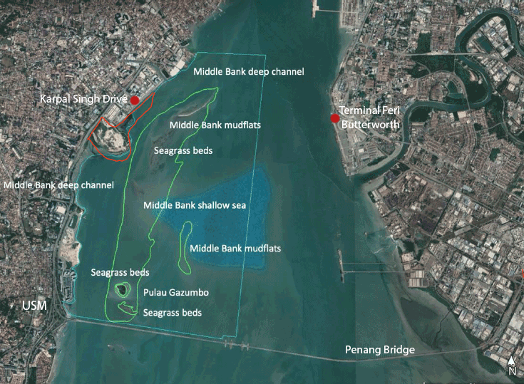
Middle Bank satellite map with a red proposed-reclamation outline near Karpal Singh Drive and labels for USM, Butterworth ferry terminal, Pulau Gazumbo, Penang Bridge and marine habitats.View full image
Supplied annotated map of Middle Bank and the proposed reclamation site outlined in red, with added coastal landmarks. Underlying map: Penang Institute / CEMACS, Figure 5-1 (2023, p. 9).Protect Karpal Singh Drive · Ecosystem ↗View full image ↓Penang Institute · Figure 5-1 · Google Earth / TerraMetrics
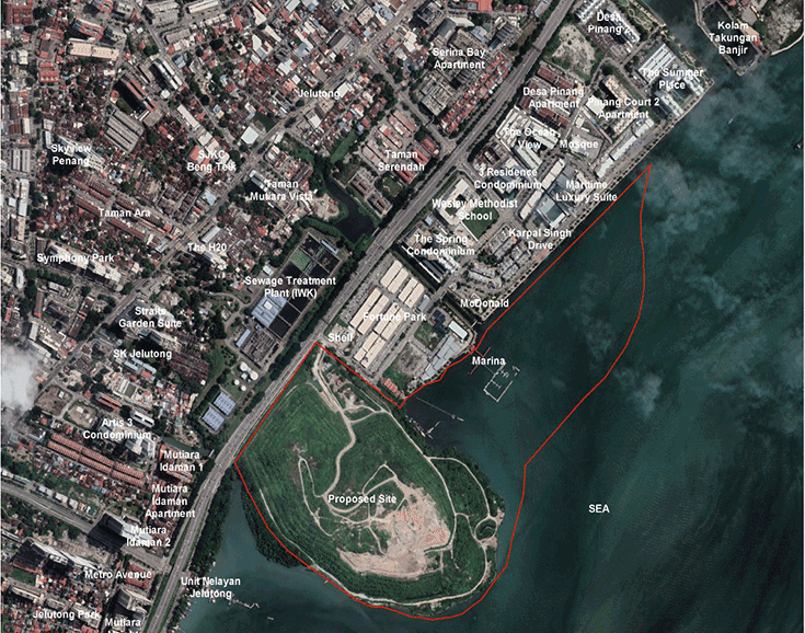
Satellite view of the Jelutong landfill and nearby sea with an approximate red project outline added by the campaign.View full image
Campaign satellite illustration of the Jelutong landfill and adjacent water, annotated with a red project outline. Source: Protect Karpal Singh Drive campaign, Ecosystem page.Protect Karpal Singh Drive · Ecosystem ↗View full image ↓

These annotated illustrations are not georeferenced surveys or authoritative project and sanctuary boundaries. The red outlines do not establish a measured habitat overlap, ecological buffer or legal status.

Four pathways that need careful assessment

These are potential mechanisms, not claims that every impact has occurred. Their significance depends on the final footprint, construction methods, local conditions and the reliability of mitigation.

Seabed conversion & habitat loss

Reclamation converts the seabed within its footprint. Any overlap with seagrass, tidal flats or feeding grounds could remove habitat and interrupt ecological connections. A georeferenced overlay is needed before stating how much of any habitat would be affected.

Which surveyed habitats lie within the final works and temporary construction areas?

Suspended sediment & less light

Dredging, filling and disturbed sediment can increase turbidity, reducing the light available to seagrass. Settling material can also cover leaves and the seabed. Exposure duration, particle size, tidal transport and species tolerance matter alongside peak concentrations.

What exposure limits, monitoring locations and stop-work triggers would protect the meadow?

Water quality & contaminant pathways

Landfill rehabilitation must consider leachate, runoff and the handling of disturbed material. Whether contaminants can reach marine receptors, and at what concentrations, requires material testing and a transparent account of containment, treatment and failure scenarios.

What testing and containment evidence address both normal operations and failures?

Currents, erosion & deposition

A changed shoreline or seabed can redirect flows and alter where sediment moves or settles. Research shows that seagrass and water movement interact, but it cannot predict this project’s outcome without local calibration, seasonal validation and assessment of nearby works together.

Do independently reviewed models assess seasonal conditions and cumulative changes?

Read the source

Read the evidence according to its purpose

An ecological inventory, a commissioned impact assessment and a community campaign answer different questions. Reading them together makes both the concern and the remaining uncertainty clearer.

Institutional publications

The institutional ecological record

The 2023 Penang Institute/CEMACS report documents Middle Bank’s ecological significance and compiles biodiversity records. It provides conservation context; it does not independently quantify the effects of this development design.

See the evidence
Citation+

Yasin, Z., Tan, A. S. H., Lee, A., Woo, S. P., & Razali, N. (2023). Protecting Penang’s marine biodiversity: Establishing the Middle Bank Marine Sanctuary (MBMS). Penang Institute.

Read the source
Institutional publications

The consultant’s conditional prediction

The EIA categorises seagrass/marine-sanctuary impact as “slight” under its assessed scenario (p. 7.224). It also acknowledges Middle Bank as a nearby receptor that may be affected and assumes 70% silt-curtain efficiency (p. 7.230). These are conditional predictions requiring scrutiny and monitoring, not observed post-construction results.

See the evidence
Citation+

YES Bizs Sdn. Bhd. (2025). Environmental impact assessment for proposed landfill rehabilitation and land reclamation works for mixed development at Seksyen 8, Bandar Jelutong, Daerah Timur Laut, Pulau Pinang [Proponent-commissioned EIA; version made publicly available on 12 February 2025 during the public feedback period; public mirror]. Prepared for PLB Engineering Berhad. https://github.com/field05/PLB-EIA-Report

Read the source
Community positions

The community’s conservation case

The Protect Karpal Singh Drive campaign questions reclamation near Middle Bank and calls for protection, independent assessment and consideration of rehabilitation without reclamation. This is an attributed advocacy position. The feasibility and ecological performance of alternatives still need comparative assessment.

See the evidence
Citation+

Protect Karpal Singh Drive Campaign. (n.d.). Middle Bank sanctuary at risk: Reclamation vs. science. Retrieved October 14, 2026, from https://protect-middle-bank.pages.dev/ecosystem

Read the source

Conservation

Five questions before decisions become irreversible

A credible assessment should let scientists, residents and decision-makers examine the same evidence.

Conservation · Pelan 6.1

01Publish the latest project design, approval conditions and georeferenced habitat and project boundaries.

02Update seasonal ecological and water-quality baselines, including fishing and coastal-community uses.

03Independently review sediment, contaminant and hydrodynamic predictions, including mitigation failures and cumulative impacts.

04Compare rehabilitation without reclamation and other designs against the same environmental and social criteria.

05Disclose monitoring data, enforceable action thresholds, responsibilities and how the proposal aligns with sanctuary planning.

Take action

Ask for evidence that can be examined.

Use the editable message to request transparent assessment, a clear explanation of the planning conflict and meaningful consideration of alternatives. Adapt it to your own concerns before sharing.

Prepare a message

Search the site

Discover a place, a process, or a piece of evidence.

Open full-size image

Open full-size image